
Deep excavation monitoring is a multi-sensor field program that combines distributed fiber optic sensing (DFOS), inclinometers, survey instruments, and pore-pressure sensors to detect ground and structural movement before it reaches serviceability or safety limits. The recommended approach is hybrid: continuous distributed sensing paired with discrete instruments and periodic optical survey, all interpreted against a documented baseline and reviewed by a senior geotechnical engineer, not left to automated thresholds alone.
The monitoring goal is early detection, not after-the-fact record-keeping. A program built on this principle tracks:
- Lateral wall or pile displacement
- Surface and building settlement
- Pore water pressure and phreatic surface position
- Support element axial force (struts, tiebacks)
- Crack widths in adjacent structures
Statistic Callout: An AI-enhanced observational method that assimilates sparse, multi-source monitoring data has been shown to improve stage predictions by 24.5% to 89.5% within ten seconds of new readings arriving, using Bayesian updating rather than static thresholds alone.
Key Takeaways
A safe deep excavation monitoring program combines DFOS, discrete sensors, and survey control with a documented baseline and senior engineering review at every alarm threshold.
| Point | Details |
|---|---|
| Baseline before anything else | Run baseline monitoring for two to four weeks before excavation to separate real movement from normal ground variability. |
| Hybrid sensor coverage | Pair continuous DFOS strain data with discrete inclinometers and survey points so one sensor failure doesn’t blind the program. |
| Three-tier alarm response | Set serviceability, investigatory, and emergency thresholds, each with a named decision-maker and a documented response. |
| AI supports, doesn’t replace, judgment | Hybrid models improve prediction accuracy but still need a senior geotechnical engineer to interpret anomalies before action. |
| Aectechnicalsg delivers the full program | Aectechnicalsg designs and oversees monitoring systems from baseline through authority submission for Singapore excavation projects. |
Table of Contents
- What Parameters Matter Most in Deep Excavation Monitoring?
- Which Sensors Should You Use for Excavation Monitoring?
- How Do You Design a Deep Excavation Monitoring Program?
- How Does AI Improve Deep Excavation Data Analysis?
- What Do Real Deep Excavation Monitoring Case Studies Show?
- How AECTechnicalSG Structures a Monitoring Engagement
- What Installation and Calibration Practices Prevent Bad Data?
- How Is Monitoring Data Transmitted from Site to Office?
- What Happens When a Monitoring Alarm Triggers?
- How Does Monitoring Data Feed Geotechnical and Structural Models?
- What Regulatory Standards Apply to Deep Excavation Monitoring?
- What the Data Actually Supports
- Get Expert Support for Your Excavation Monitoring Program
- Frequently Asked Questions
- Sources
What Parameters Matter Most in Deep Excavation Monitoring?
Every parameter on a monitoring plan exists because it maps to a specific failure mechanism, not because it is easy to measure.
- Lateral wall displacement is the most direct proxy for how a retaining system is actually performing against its design assumptions. Excessive movement signals that soil pressure or support stiffness has departed from the model, and most design codes set explicit allowable displacement limits tied to wall height and soil type.
- Surface settlement gets mapped in a zone extending roughly one to two times the excavation depth from the pit edge, since that is where ground loss and drawdown effects typically concentrate. Field studies of soft-soil excavations have recorded settlement peaks located around 12 meters from the pit edge rather than directly adjacent to it, which is why a monitoring grid limited to the immediate perimeter often misses the real deformation front.
- Pore water pressure monitoring controls the phreatic surface and directly affects effective stress calculations. A rising or unexpectedly fluctuating pore pressure reading can mean a failed dewatering system or a breach in a cutoff wall, either of which changes the stability calculation instantly.
- Support axial force in struts and tiebacks, tracked with strain gauges or load cells, confirms whether the bracing system is carrying the load the design intended. Crack meters on adjacent structural members catch distress before it becomes visible spalling.
- Vibration from piling, demolition, or nearby traffic degrades sensor accuracy and can independently threaten adjacent structures, so it gets logged alongside displacement data rather than treated as background noise.
Which Sensors Should You Use for Excavation Monitoring?
Instrument selection is a matter of matching sensor physics to the failure mode you are worried about, not defaulting to whatever was used on the last job.
- Inclinometers remain the standard for subsurface lateral movement profiles. Casings need to be installed plumb, extend well below the anticipated toe of movement, and get read on a fixed schedule, typically weekly during active excavation and daily near critical stages.
- DFOS delivers continuous strain data along the full length of a pile or wall rather than discrete points, which matters when a failure could initiate anywhere along the member. Fiber needs to be tight-buffered and run inside protective sleeves to survive grouting and concreting, and temperature-monitoring fibers are essential for compensation, since grouting can raise local temperatures by tens of degrees and skew raw strain readings if uncorrected.
- Total stations and GNSS survey networks track surface settlement and horizontal ground movement at fixed prism points, cross-checking what inclinometers and DFOS report at depth.
- UAV photogrammetry adds fast, wide-area progress and surface change detection; automated UAV and deep-learning workflows can flag fence breaches or unexpected excavation encroachment without a surveyor walking the site.
- Piezometers, whether standpipe or electronic transducer types, get placed at multiple depths across the excavation footprint to define the groundwater profile, particularly near any dewatering wells or cutoff walls.
Pro Tip: Never rely on a single sensor technology for a critical monitoring point. Pair a DFOS strain profile with a discrete inclinometer reading at the same wall panel, so a fiber break or a stuck probe doesn’t leave you blind at the moment it matters most.
DFOS is particularly effective where continuous coverage along a structural member matters, but it demands more careful installation than a point sensor, and that installation discipline is what separates usable data from noise.
How Do You Design a Deep Excavation Monitoring Program?
A monitoring layout built without a real baseline period is a layout that will generate false alarms the first time the temperature swings ten degrees overnight.
- Baseline monitoring should run for at least two to four weeks before excavation starts, long enough to capture diurnal cycles and at least one significant weather event. This baseline period is what lets you set alarm thresholds that reflect real construction-induced movement rather than normal ground breathing, and capturing that natural variability up front costs far less than chasing a false alarm mid-excavation.
- Layout principles follow the geometry of risk: settlement points on a grid tighter near the pit edge and near any sensitive adjacent structure, inclinometer lines at panel corners and mid-span locations, DFOS runs along the full retaining wall where possible, and survey control points anchored well outside the influence zone.
- Measurement cadence scales with excavation stage and risk level. Early stages might warrant weekly readings; once excavation passes critical depth or approaches a sensitive structure, that shifts to daily or continuous automated readings.
- Alarm tiers typically run three levels: a serviceability threshold that triggers a review, an investigatory threshold that pauses non-critical work pending engineering assessment, and an emergency threshold that halts excavation and mobilizes an immediate site response.
- Reporting protocol defines who receives what and when: daily automated summaries to the site team, weekly consolidated reports to the client and authority, and verification site visits whenever a threshold is crossed, all documented for the compliance record.
How Does AI Improve Deep Excavation Data Analysis?
Raw monitoring data arrives with noise, dropouts, and the occasional corrupted reading, and pretending otherwise is how bad decisions get made on good instruments.
- Automated filtering strips obvious sensor glitches and interpolates short gaps, but graph recurrent neural network frameworks for spatio-temporal imputation now handle more substantial missing or corrupted stretches by learning spatial correlation across nearby sensors rather than just interpolating in time.
- A workable real-time architecture runs edge acquisition at the sensor, cloud ingestion for storage and processing, a dashboard for the project team, and an alerting layer that pages the right person the moment a threshold is crossed.
- Hybrid deep-learning models combining convolutional and recurrent layers with attention mechanisms have improved pile-top displacement prediction accuracy by 5% to 12% over simpler neural network baselines, but these models need site-specific training data and lose accuracy fast when applied to soil conditions they weren’t trained on.
- The observational method, updated with Bayesian assimilation of live readings, is what actually closes the loop between prediction and reality, and experienced monitoring teams still keep a senior geotechnical engineer as the final arbiter on any anomaly the model flags.
Pro Tip: Treat any AI-generated prediction as a second opinion, not a verdict. Cross-check it against a manual reading and a physical site inspection before you authorize remediation work.
What Do Real Deep Excavation Monitoring Case Studies Show?
A 2025 study of a Dalian deep-excavation project trained a CNN-LSTM-SAM hybrid model on DFOS strain data and found it outperformed a standalone LSTM model by 10.85% and a plain CNN-LSTM model by 5.63% in predicting pile-top displacement at one monitoring point. The practical lesson: hybrid models add real predictive value, but only when trained against the specific site’s own DFOS history, not a generic dataset.
A secant pile wall field study using BOTDA distributed fiber sensing recorded strain and temperature continuously through grouting and excavation, observing temperature rises near 69 degrees Celsius during grouting that would have corrupted raw strain readings without a dedicated compensation fiber. The team converted strain profiles to lateral displacement using numerical integration and finite-difference methods, a workflow that depends entirely on getting the fiber installation and temperature correction right from day one.
Separately, field monitoring of a mucky soft-soil excavation recorded horizontal displacements near 70 to 80 millimeters, with settlement exceeding design limits at points well inside the presumed safe zone. Lessons that repeat across these projects:
- Baseline data is what makes a threshold meaningful rather than arbitrary.
- Sensor redundancy catches the failures that a single-technology program misses.
- Installation quality, especially temperature compensation on fiber optic runs, determines whether the data is usable at all.
- A human engineer signs off before any remediation, regardless of what the model recommends.
How AECTechnicalSG Structures a Monitoring Engagement
A monitoring program is only as good as the engineering judgment behind its design, which is why Aectechnicalsg pairs field instrumentation with the same geotechnical instrumentation expertise and soil-structure interaction analysis used across its structural and geotechnical practice.
A typical engagement runs through:
- Site assessment and risk classification against adjacent structures
- Monitoring system design, including sensor selection and layout
- Installation oversight and calibration verification
- Ongoing data review with defined alarm response
- Authority submission support for the monitoring records regulators expect
Clients should expect baseline reports, calibration certificates, alarm logs, and weekly monitoring summaries as standard deliverables, not add-ons requested after the fact.
What Installation and Calibration Practices Prevent Bad Data?
A monitoring instrument that reads incorrectly is arguably worse than no instrument at all, because it creates false confidence right up until the moment it matters.
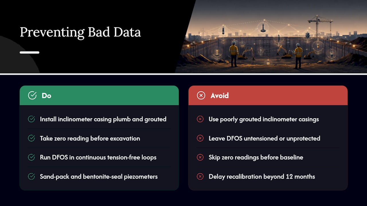
Inclinometer casings need to be installed plumb and grouted properly against the surrounding soil; a poorly grouted casing can move independently of the ground it’s meant to represent, producing readings that look like real deformation when they’re actually casing slip. Zero readings must be taken immediately after installation and before any excavation begins, since that first reading becomes the reference point every future measurement is compared against.
DFOS installation is more exacting still. The fiber must run in continuous tension-free loops, protected inside sleeves during concrete placement, and paired with a dedicated temperature-monitoring fiber for compensation, since uncorrected thermal expansion during curing or grouting can be mistaken for structural strain. Piezometers need proper sand-pack and bentonite seal placement at the target depth to avoid cross-contamination between aquifer layers, which would otherwise produce a pore pressure reading that reflects the wrong stratum entirely.
Total station and survey control points require redundant reference benchmarks located well outside the zone of ground influence, checked periodically against a fixed geodetic datum. Crack meters and strain gauges need a documented zero reading and a re-calibration schedule, typically every six to twelve months, since electronic drift accumulates even in stable installations. Every instrument, regardless of type, should carry a calibration certificate on file before its first reading counts as usable baseline data.
How Is Monitoring Data Transmitted from Site to Office?
Data transmission on an active excavation site has to survive conditions that would break a typical office network: standing water, heavy vibration, moving equipment, and long cable runs across an open pit.
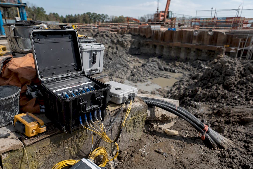
Wired transmission remains the standard for DFOS installations, since fiber optic cable itself carries the signal and needs a data logger at one end connecting to site power and a network uplink. Wireless sensor networks, using low-power protocols suited to intermittent connectivity, handle discrete instruments like piezometers and crack meters spread across a site where running cable back to a central point isn’t practical.
Cellular and LPWAN connectivity increasingly bridges site data loggers to cloud platforms without requiring a fixed internet line, which matters on sites where permanent infrastructure hasn’t been established yet. A construction-focused AI software platform can then ingest that streamed data alongside schedule and progress information, giving the project team a single dashboard rather than separate feeds from separate systems.
Redundancy matters here as much as it does with sensor selection. A site relying on a single cellular connection for its alerting layer has a single point of failure that can go dark exactly when a storm or power outage makes monitoring most urgent. Practical designs pair a primary transmission path with a local data logger that stores readings on-site, so a connectivity gap doesn’t mean a data gap. Data should sync automatically once connectivity restores, with timestamps preserved so the record shows exactly when each reading was actually taken versus when it reached the dashboard.
What Happens When a Monitoring Alarm Triggers?
The value of an alarm tier system collapses if nobody has rehearsed what happens the moment a threshold is actually crossed.
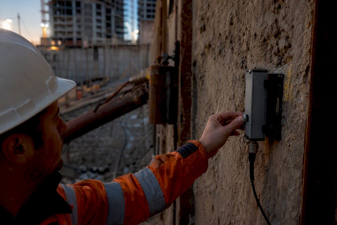
A serviceability-level alarm should trigger an engineering review within the same working day, typically a check of the reading against recent trends and a site walk to confirm the instrument itself isn’t malfunctioning. An investigatory-level alarm escalates further: non-critical work near the affected zone pauses, a senior geotechnical engineer inspects the site in person, and additional readings get taken outside the normal cadence to confirm the trend is real rather than a single anomalous data point.
An emergency-level alarm demands an immediate stop to excavation activity in the affected zone, notification to the site safety officer and project management, and mobilization of a response team that may include additional shoring, load relief, or evacuation of the immediate area if a structural safety concern is confirmed. Every tier needs a documented decision tree naming who has authority to declare each level and who has authority to stand it down, because ambiguity about decision rights during an active alarm is where response time gets lost.
Post-alarm, every triggered threshold should generate a written record: the reading that triggered it, the response taken, and the engineering rationale for resuming or continuing to pause work. That record becomes part of the authority submission trail and the project’s defensible safety case if the incident is ever reviewed.
How Does Monitoring Data Feed Geotechnical and Structural Models?
Monitoring data earns its full value only when it flows back into the models that predicted the excavation’s behavior in the first place, closing the loop between design assumption and field reality.
The observational method formalizes this: a design team sets a predicted response range before construction, then compares live monitoring data against that range at each stage, adjusting either the construction method or the model itself when field readings diverge. This is where soil-structure interaction analysis becomes a living document rather than a one-time calculation, updated as pore pressure, displacement, and settlement data accumulate through the excavation sequence.
Structural models for support elements benefit the same way. A strut load cell reading that exceeds the design prediction by a meaningful margin should trigger a review of the structural model’s assumed soil stiffness or surcharge loading, not just a note in a monitoring log. The geotechnical analysis process that produced the original design becomes the same process used to reinterpret it mid-construction.
Predictive models trained on early monitoring data can also flag likely behavior in later excavation stages before they happen. The AI-empowered observational method referenced earlier in this guide works precisely this way, assimilating stage-one data to sharpen stage-two and stage-three predictions. The output is only as trustworthy as the underlying model calibration, though, which is why every model-based prediction needs a documented confidence range and a named engineer responsible for interpreting it against reality on site.
What Regulatory Standards Apply to Deep Excavation Monitoring?
Regulatory requirements for deep excavation monitoring generally sit within a jurisdiction’s broader building and construction safety framework rather than existing as a single stand-alone code, and requirements scale with the excavation’s risk classification, proximity to existing structures, and groundwater conditions.
Most frameworks require a documented monitoring plan submitted before excavation begins, specifying instrument types, layout, alarm thresholds, and reporting frequency. Authorities typically expect baseline data collected before construction starts, calibration certificates for every instrument, and a defined escalation protocol tied to the alarm tiers described earlier in this guide. Regulatory compliance documentation for these submissions needs to demonstrate not just that monitoring exists, but that the program was designed against the specific risk profile of the site and its neighbors.
Ongoing compliance during construction usually requires periodic verification visits by a qualified person, retained records of every alarm event and the response taken, and formal reporting to the relevant authority at defined milestones or whenever a threshold escalation occurs. Structural repair or remediation triggered by a monitoring alarm typically requires its own separate authority notification and sign-off before work proceeds. Because these requirements vary by jurisdiction and by project risk category, the monitoring plan itself should be reviewed against the applicable local building authority’s current submission requirements rather than assumed from a previous project in a different market.
What the Data Actually Supports
Most conventional advice on this topic treats AI and DFOS as add-ons to a traditional monitoring plan, bolted on for extra reassurance. The evidence points somewhere else: DFOS plus AI-assisted observational updating isn’t a supplement to good monitoring, it’s becoming the mechanism through which good monitoring happens at all, because it catches the spatial and temporal patterns a discrete sensor grid physically cannot see.
Where conventional advice falls short is the assumption that more sensors automatically mean better decisions. They don’t, if nobody has budgeted time for baseline capture or trained the model on this site’s own soil behavior rather than a generic dataset. The single highest-leverage move for most projects isn’t buying more instruments. It’s committing to a real baseline period and a genuine human review step before any alarm becomes a decision.
Readers should prioritize sensor redundancy and installation discipline over chasing the newest predictive model, because a hybrid neural network trained on bad fiber data will produce confident, wrong answers faster than a human ever would.
Get Expert Support for Your Excavation Monitoring Program
Aectechnicalsg is the alternative to piecing together a monitoring program from separate vendors, since it delivers geotechnical design, instrumentation oversight, and authority submissions under one consultancy engagement rather than three separate contracts you have to coordinate yourself.

That matters most at the design and submission stage, where a monitoring plan needs to satisfy both engineering judgment and regulatory review at the same time. Aectechnicalsg’s engineering consultancy services cover site assessment, instrumentation layout, installation oversight, and the ongoing data review that keeps a monitoring program defensible if it’s ever questioned by an authority or an adjacent property owner. The firm also handles PE endorsement and authority submissions directly, so the monitoring plan and the regulatory paperwork move through the same team rather than getting translated between separate consultants.
If your excavation project needs a monitoring program designed around your specific soil conditions and adjacent structures, reach out to Aectechnicalsg for a site assessment and monitoring design proposal.
Frequently Asked Questions
What is deep excavation monitoring?
Deep excavation monitoring is a field program using sensors like DFOS, inclinometers, piezometers, and survey instruments to track ground and structural movement during excavation, allowing engineers to detect problems before they exceed safety or serviceability limits.
How often should excavation monitoring readings be taken?
Cadence should scale with risk and excavation stage: weekly during early, low-risk stages, shifting to daily or continuous automated readings once excavation passes critical depth or work approaches sensitive adjacent structures.
What triggers a monitoring alarm on an excavation site?
An alarm triggers when a measured parameter, such as wall displacement, settlement, or pore pressure, crosses a threshold set during baseline monitoring, escalating through serviceability, investigatory, and emergency tiers depending on severity.
Can AI replace manual review in excavation monitoring?
No. AI models improve prediction accuracy and help fill data gaps, but experienced teams still keep a senior geotechnical engineer as the final decision-maker on any anomaly the model flags before authorizing remediation.
Why is baseline monitoring necessary before excavation starts?
Baseline data captures normal diurnal and seasonal ground movement, giving engineers a reference point to distinguish real construction-induced deformation from natural variability, which prevents false alarms and unreliable thresholds.
Sources
- Monitoring and deformation of deep excavation engineering based on DFOS technology and hybrid deep learning | Scientific Reports
- AI-empowered observational method for deep excavations | Tunnelling and Underground Space Technology
- Towards reliable deep excavation monitoring through graph recurrent neural network-based spatio-temporal imputation | Reliability Engineering & System Safety