
Settlement monitoring methods fall into five families: manual surface markers, optical/geodetic surveying, GNSS, remote sensing (InSAR/TLS/UAV), and subsurface sensors, often paired with automated systems (AMTS/IoT/SHM). The selection rule is straightforward: use manual leveling for low-risk periodic checks, deploy geodetic or automated systems for continuous or high-risk structures, and reserve remote sensing for area-scale trend detection across sites too large for point instruments.
TL;DR:
- Manual surveys and settlement plates are suitable for low-risk projects with infrequent readings, ensuring accuracy within 1 to 2 millimeters.
- High-accuracy geodetic techniques like total stations and continuous GNSS are effective for critical points but less reliable in dense urban environments.
- Subsurface sensors such as piezometers, extensometers, and inclinometers detect below-ground movements that often precede surface settlement.
- Automated systems with IoT and SHM dashboards are ideal for high-risk structures, providing real-time alerts and reducing manual labor.
- Proper planning, including baseline surveys, deliberate point placement, and threshold setting, enhances monitoring reliability and regulatory compliance.
Table of Contents
- What Are the Main Settlement Monitoring Methods?
- Which Instruments and Devices Track Structural Settlement?
- How Do Surveying and Geodetic Techniques Measure Settlement?
- Why Do Subsurface Sensors Matter for Settlement Analysis?
- How Do Automated Monitoring Systems Improve Settlement Tracking?
- How Do You Design a Settlement Monitoring Plan?
- How Is Settlement Data Processed and Interpreted?
- What Field Conditions Change Which Method You Should Use?
- What We’ve Learned Deploying Settlement Monitoring on Real Projects
- How AECTechnicalSG Supports Your Monitoring Program
- Sources
- FAQ
What Are the Main Settlement Monitoring Methods?
Each method family answers a different question about ground and structural movement. Surface markers and manual leveling suit low-risk, budget-conscious projects where periodic readings satisfy regulatory checkpoints. Optical and geodetic techniques, including total stations, step up when you need repeatable sub-millimeter accuracy on a handful of critical points. GNSS delivers continuous 3D positioning across open sites but struggles near tall buildings. InSAR, terrestrial laser scanning (TLS), and unmanned aerial vehicle (UAV) photogrammetry cover wide areas without contact instrumentation, useful when a whole facade or hillside needs trend data rather than single-point precision. Subsurface sensors track what’s happening below grade, where the actual settlement driver often originates.
- Surface markers/manual surveying: low cost, periodic readings, ideal for low-risk retaining walls or minor renovations.
- Optical/geodetic (total station, leveling): high accuracy, moderate cost, best for critical structural points near excavations.
- GNSS: continuous coverage, cost-effective over large open areas, weak in dense urban corridors.
- InSAR/TLS/UAV: area-scale coverage, no ground contact required, suited to facades, slopes, and inaccessible zones.
- Subsurface sensors: direct measurement of pore pressure and layered ground movement, essential near deep excavations.
Which Instruments and Devices Track Structural Settlement?
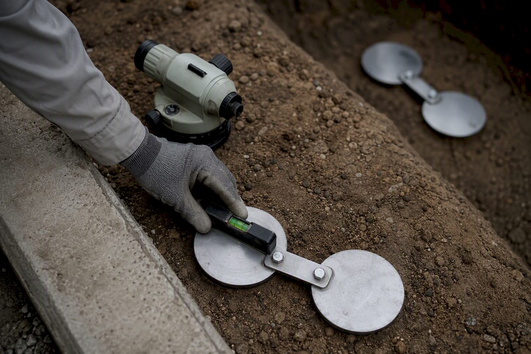
Settlement plates and markers remain the workhorses of ground settlement techniques. A plate installed at the base of a fill or foundation, read against a fixed benchmark on a weekly or monthly cadence, typically resolves movement to within 1 to 2 millimeters when leveling is done correctly. Crackmeters track the opening or closing of existing cracks across joints, usually mounted directly over the crack with epoxy anchors on both sides. Hydrostatic level cells measure relative elevation changes through a fluid-filled tube network, a good fit where line-of-sight surveying isn’t practical, such as between floors of an occupied building. Tiltmeters catch rotational movement in retaining walls or tower structures, while LVDTs (linear variable differential transformers) provide continuous, high-resolution displacement data for structural joints under load.
Borehole extensometers measure compression or extension at multiple depths in a single hole, which is how you separate settlement happening in a shallow fill layer from consolidation in a deeper clay stratum. In-place inclinometers, left permanently in a casing, track lateral ground movement continuously rather than requiring a probe survey each time.
- Settlement plates: read against a stable benchmark, accuracy typically ±1 to 2mm.
- Crackmeters and LVDTs: continuous readout, best for active structural joints.
- Hydrostatic level cells: useful indoors or where sightlines are blocked.
- Borehole extensometers and in-place inclinometers: depth-resolved data for layered soils.
Calibration matters as much as installation. Recheck zero-readings against an undisturbed reference point every six months, and inspect cable connections and protective housings after any nearby construction activity. For a deeper breakdown of device selection by soil condition, see this field guide to geotechnical instrumentation.
Pro Tip: Install at least one redundant settlement plate per critical zone. A single instrument reading an anomaly could mean real movement or a disturbed marker. Two independent readings pointing the same direction remove that doubt fast.
How Do Surveying and Geodetic Techniques Measure Settlement?
High-precision leveling, run as closed loops between fixed benchmarks, remains the gold standard for sub-millimeter vertical control on critical structures. Motorized total stations and automated motorized theodolite systems (AMTS) extend that precision into continuous monitoring, and reflectorless AMTS setups skip the need to mount prisms on every target point, which speeds deployment considerably.
GNSS gives continuous 3D data across open sites, but multipath and satellite obstruction in dense urban environments reduce its reliability, so most consultants pair it with atmospheric correction models or fall back on optical methods downtown. TLS and UAV photogrammetry generate dense point clouds that catch facade bulging or roof settlement without physical contact, particularly valuable where access is restricted. InSAR tracks large-area ground trends from satellite data with revisit times measured in days, strong for regional subsidence but not for single-building alarms needing same-day response.
- Leveling loops: sub-millimeter accuracy, slow but highly reliable.
- AMTS (reflectorless): automated, continuous, reduces field labor.
- GNSS: continuous but degraded in urban canyons.
- TLS/UAV: contactless, area coverage, ideal for facades and roofs.
- InSAR: regional trends, multi-day revisit cycles.
Why Do Subsurface Sensors Matter for Settlement Analysis?
Most structural settlement traces back to something happening below grade, usually a change in pore water pressure or a shift in an underlying soil layer. Piezometers and pore-pressure sensors flag rising groundwater or dewatering effects long before surface markers show movement, which is why excavation projects near sensitive foundations almost always specify them alongside surface instruments.
Extensometers and inclinometer chains resolve exactly where in the soil column movement is occurring, separating a settling fill layer from deeper consolidation. That distinction changes the engineering response entirely: one might call for surcharge removal, the other for a redesigned foundation. Borehole instruments need protective casings and clear labeling at the surface, since a damaged or buried wellhead becomes useless data the moment construction traffic rolls over it. Understanding how soil and structure interact below the surface helps explain why these readings often move before anything visible happens at grade, a topic covered in more depth in this soil-structure interaction guide.
- Piezometers: early warning for groundwater-driven settlement.
- Extensometers: depth-resolved compression data.
- Inclinometer chains: continuous lateral movement profiles.
How Do Automated Monitoring Systems Improve Settlement Tracking?
Automated settlement monitoring systems remove the daily labor bottleneck that limits how often manual surveys can realistically run. Reflectorless AMTS setups eliminate prism installation and maintenance while still delivering accurate change detection under real field conditions, using a two-step process that first scans for geometry changes across the monitored surface, then quantifies movement only in flagged areas. That approach cuts processing load significantly compared to analyzing every point equally.
IoT sensor networks extend this further, streaming readings from crackmeters, tiltmeters, and piezometers into a central platform, though power supply, wireless range, and data security all need planning before deployment, not after. Structural health monitoring (SHM) integration ties these feeds into dashboards with tiered thresholds, so a minor drift triggers a routine flag while a rapid shift triggers an immediate alert to the engineer on record. Comparative research on monitoring techniques recommends exactly this kind of automation and SHM integration for high-risk structures.
- Reflectorless AMTS: no prisms, continuous readings, lower field labor.
- IoT sensor networks: real-time data, requires power and connectivity planning.
- SHM dashboards: tiered alerts, remote access for engineering teams.
Automation earns its cost on projects with continuous risk exposure, adjacent heritage buildings, deep excavations, or tight regulatory reporting windows. For lower-risk work, the added infrastructure often outweighs the benefit. Construction teams tracking daily progress alongside settlement data sometimes layer in site management tools like Anodos to keep monitoring schedules synced with the broader build timeline.
Pro Tip: Set your alert thresholds before the first reading, not after you see a number you don’t like. Retroactively adjusting thresholds erodes the credibility of the entire monitoring program in front of regulators and clients alike.
How Do You Design a Settlement Monitoring Plan?
A defensible monitoring plan starts with a baseline survey run as a closed loop between fixed benchmarks, ideally taken before any excavation or loading begins. From there, the plan needs monitoring points chosen deliberately, not just wherever access is easiest.
- Establish baseline readings from at least two independent reference benchmarks outside the zone of influence.
- Place monitoring points at structural elements carrying the highest load or closest to the excavation or fill boundary.
- Set frequency by risk tier: continuous or daily for active excavation adjacency, weekly for stable structures under moderate load, monthly for long-term infrastructure checks.
- Define threshold tiers (alert, action, and stop-work levels) tied to specific movement rates, not just cumulative totals.
- Deliver reporting packages that include raw readings, trend charts, and a clear statement against each threshold tier for engineering and regulatory review.
Comparative monitoring studies increasingly recommend automating classical geodetic measurement where structures carry elevated risk, rather than relying solely on periodic manual rounds. For excavation-specific point selection and cadence guidance, this deep excavation monitoring guide covers the adjacent-property protection angle in more detail.
How Is Settlement Data Processed and Interpreted?
Raw readings only become useful once they’re checked and modeled. Least-squares adjustment closes out small discrepancies in leveling and total-station loops, giving you a statistically sound elevation value rather than a single unverified reading. Change-point and discontinuity detection algorithms flag when a monitoring point’s behavior shifts abruptly, often the first sign of a new settlement mechanism rather than steady consolidation.
Space–time cube visualization, paired with forest-based machine-learning forecasting, has shown it can support short-term forecasts of two to three years and automated detection of discontinuities in building settlement datasets, often outperforming deep-learning models when the monitoring history is limited. This kind of GeoAI approach is covered further in this piece on AI and machine learning in structural health monitoring.
- Least-squares adjustment: statistically validated elevation and position data.
- Discontinuity/change-point detection: flags abrupt shifts for investigation.
- Space–time cubes and GeoAI: short-horizon forecasting and hotspot analysis.
- Cross-checks: validate automated outputs against independent manual surveys.
| Processing method | Primary use | Typical output |
|---|---|---|
| Least-squares adjustment | Closing leveling/total-station loops | Validated elevation values |
| Discontinuity detection | Flagging abrupt behavior changes | Alert on localized movement |
| Space–time cube + GeoAI | Short-term trend forecasting | 2 to 3 year prediction window |
| Clustering algorithms | Grouping flagged change areas | Reduced false-positive rate |
What Field Conditions Change Which Method You Should Use?
Dense urban sites degrade GNSS accuracy through multipath and blocked satellite visibility, which is exactly why optical AMTS and TLS remain the default in city-center excavation work. Reflectorless measurement cuts field labor but demands regular recalibration against lighting and atmospheric shifts, since a sunny afternoon reading and an overcast morning reading on the same target can differ enough to trigger a false alarm if uncorrected.
Thermal expansion of structural elements produces daily cycling that mimics settlement if you’re not tracking temperature alongside displacement. Every formal report needs a clear chain of custody: who took the reading, on what instrument, calibrated when.
- GNSS: unreliable in urban canyons, prefer optical or TLS instead.
- Reflectorless AMTS: less field labor, needs environmental recalibration.
- Thermal cycling: log temperature to separate it from true settlement.
Pro Tip: Cross-check any automated alert against one independent manual reading before escalating to a client or regulator. It costs an hour and saves a reputation.
What We’ve Learned Deploying Settlement Monitoring on Real Projects
Early baseline surveys with clearly defined thresholds prevent more disputes than any instrument upgrade ever will. Urban excavation work almost always performs best with a mix: optical AMTS for critical points, subsurface piezometers for the excavation zone, and periodic manual cross-checks. Automation and clean reporting shorten disputes because everyone is arguing from the same numbers instead of competing estimates.
— Aman
How AECTechnicalSG Supports Your Monitoring Program
Choosing the right settlement monitoring methods is only half the job. Getting a program designed, deployed, and defensible in front of Singapore’s regulatory bodies is the other half, and it’s where most in-house teams run out of bandwidth. AECTechnicalSG works project-level: structural and geotechnical consultation, monitoring plan design tied to your risk profile, and direct facilitation of BCA and URA submissions so your monitoring data holds up under review, not just under a spreadsheet.

The typical engagement runs survey first, then design, then deployment oversight, then reporting, with an engineer following the project from baseline through final sign-off. If your site needs periodic structural or facade inspection layered on top of settlement tracking, that falls under the same structural and geotechnical consultation services. Reach out for a scoping conversation and a quotation tailored to your project specifics.
Sources
- Monitoring building settlements using space–time cubes and geospatial AI (International Journal of Civil Engineering)
- Automated building monitoring system based on reflectorless measurements: a case study of the IMSGeo system (Sensors, 2025)
- Practical considerations for GNSS in settlement monitoring (Natural Publishing, 2024)
- Comparative monitoring techniques and integration with SHM (Measurement Journal, 2024)
FAQ
What Are the Three Types of Soil Settlement?
Soil settlement typically occurs as elastic (immediate) settlement, primary consolidation settlement, and secondary consolidation (creep) settlement. Elastic settlement happens instantly under load, primary consolidation unfolds as pore water drains from soil over weeks or months, and secondary consolidation continues slowly over years as soil particles rearrange.
What Is a Settlement Monitoring Point?
A settlement monitoring point is a fixed, physically marked location, such as a settlement plate, survey nail, or prism, where elevation or position is measured repeatedly over time to track ground or structural movement. Points are selected at locations tied to structural load or proximity to excavation, not arbitrary spots.
What Is Ground Settlement Monitoring and How Is It Used?
Ground settlement monitoring tracks vertical and lateral ground movement over time using instruments like settlement plates, extensometers, and geodetic surveys, then compares readings against a fixed baseline. It’s used to verify that excavation, fill placement, or dewatering activities aren’t causing unacceptable movement in nearby structures or infrastructure.
How Do You Calculate Settlement in Soil?
Settlement calculations combine elastic settlement, primary consolidation (based on soil compressibility and effective stress change), and secondary consolidation estimates, typically derived from geotechnical lab testing and site investigation data. Field monitoring readings then verify whether actual settlement tracks the predicted values, and deviations trigger the plan’s threshold response.
Does AECTechnicalSG Design Settlement Monitoring Plans?
Yes, AECTechnicalSG provides structural and geotechnical engineering consultation that includes monitoring plan design, instrument selection guidance, and facilitation of related authority submissions in Singapore. Pricing is scoped per project and available on request through the services page.